~~~~~~~~~~~~~~~~~~~~~~~~~~~~~~~~~~~~~~
We have been watching the cauldron bubble and gurgle for the last few days in the Bay of Campeche, and finally the watched cauldron did begin to boil During the mid-morning, at the time that El Gringo Viejo told his better three-quarters that it would happen,it happened.
Suddenly, we are back where we were about three years ago when the rains came to the Sierra El Cautivo and when it was over, there have been a cumulative 55 inches of rain in about a week, all falling in the in the catchments of various rivers, the Rios San Pedro, Guayalejo, Puricficacion, Blanco, San Marcos, and, of course, the Corona (aka Santa Engracia). The latter is the river that runs 200 yards away from the front door of your home in Mexico. We are rather much stuck here, because of the lack of a title in hand for my new old pickup. We are in that never-never land of having only the State issued form that says that we have done all necessary to obtain the title, and we are waiting in this penumbra until the document actually arrives.
There is no complaint, because the young lady told us it would be two to three weeks for the document to make it to one of our secret mailboxes in an undisclosed location. If anything could be done, we would have already called Obama a long time ago. So here we are. It's a little like trying to schedule a weekend on the Boardwalk at Atlantic City.
So that all will be aware, the peculiar chart above-left shows the percentage probability of a locale receiving more than 16 inches of rain within the next 120 contiguous hours. That is, of course, five days beginning 01:00 AM CDT 13 September 2013 . The purple area at the lower area of the chart pertains almost entirely to the State of Oaxaca and a swath in the open Pacific Ocean. Our area, as many OROGs know is in the dark purple in the middle of the upper-left quadrant of the chart. We are towards the lower end of the dark purple part of that long thin, parallel-to-the-Sierra Madres portion of Mexico's geography.
We should disabuse AlGore from taking credit for the "incredible" forecast. And, while we are at it, beseech any and every newsey-type person, weathermanperson, and anchor or anchoretteperson...FOX people especially included....to please stop saying the word "incredible" while showing a bolt of lightning hitting a (tree)(building)(house)(Saint Bernard dog)(mother-in-law). These things are not incredible. They are not "beyond the ability to comprehend, understand, or even know". And while I am at it, all FOXNews people must from this day forward, when asked, "How are you?" respond "Well" and not "Good". I find it incredibly frightening to think that my people cannot speak well Englishperson.
Anyway, AlGore must recognise that the above rainfall values are relatively uncommentworthy in terms of records of any kind. There are various places throughout Texas and Northeastern Mexico that have recorded 12 inches in a 24-hour period. A small community west of San Antonio, Texas named D'hanis had a 28 inch recording during the drought-breakers in April, 1935. This began a episode of flooding in the Country of 1,100 Springs of Central Texas that lasted through until July of that year. Nearly 21 years later that area would have another episode with similar rainfall values. Rains of 3 to 10 inches in that part of Texas might make the news for one day, unless there is a wreck out on State 16. If that happens, folks will have to read about the rains in next week's Uvalde Avalanche.
To wit:
(El Gringo Viejo urges all to click onto "A Narrow Escape" whose linkage is found in the heading immediately below.)
(El Gringo Viejo urges all to click onto "A Narrow Escape" whose linkage is found in the heading immediately below.)
THE TEXAS FLOOD OF 1935
The Great Flood of 1935
by Edward Aquifer
Vintage photos courtesy TXDoTA Narrow Escape
Excerpted from the diary of Maryleene Bolen Christensen
by Edward Aquifer
Vintage photos courtesy TXDoTA Narrow Escape
Excerpted from the diary of Maryleene Bolen Christensen
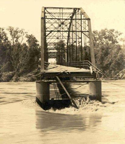
| 1935 Flood - Colorado River Bridge in Columbus, Texas Photo courtesy Nesbitt Memorial Library 00160 |
The April showers of 1935 may or may not have brought May flowers. If they had, they would almost certainly have been swept away into the Gulf of Mexico. Central and South Central Texas experienced heavy rains that Spring which greatly affected Austin, San Antonio and lesser cities like Junction, Uvalde and D'Hanis.
Although Texas was hit with record-breaking rainfall in 2007, vastly improved infrastructure prevented the devastation which Central Texas and the Hill Country suffered in the 30s. (See Rob Hafernik's Dam Fun: A July 4th Trip Up the Chain of Highland Lakes.) The 2007 flooding around Burnet, Marble Falls and Cedar Park brought nearly 20 inches of rain in a 24-hour period which is far more than the 9.21 inches of rain Austin received for the month of May 1935 or the 9.71 inches that June. But when one factors in ground saturation and no run-off channels, the resulting damage of the 1935 rains was far worse. |
 |
| 1935 Flood - Austin, Texas Photographer: H.M. Stene, a cartographer for TXDoT |
 |
| 1935 Flood - Austin, Texas Photographer: H.M. Stene |
 |
| 1935 Flood - Austin, Texas Courtesy of Austin History Center, PICA 008484-A |
In 1935, while Austin was receiving its deluge, San Antonio was hit even harder with 14.07 inches in May with 8.41 inches the next month. The stores around Alamo Plaza were flooded in late May and tiny D'Hanis, Texas reported a hard-to-believe 20-24 inches of rain in just 2 Hours and 45 Minutes.
|
 |
| D'Hanis after the 1935 Flood |
 |
| View of Cibolo Creek Bridge on Highway 66 North of San Antonio River near flood stage. |
Early to mid-June rains approached 20 inches in many other smaller communities from Uvalde to Austin. The Llano, Colorado and Pedernales Rivers all reached flood stage, affecting the cities of Junction, Llano, and Fredericksburg. On June 14 and 15 the Colorado River was just 1 foot below the record reached in July of 1869.
|
 |
| Llano River Bridges in Llano, Texas |
 |
| June 1935 flood in Junction, Texas |
 |
| The 1935 flood in Junction, Texas |
The Llano River crested at its record level ever (at that time). June also brought flooding on the Nueces River and West Nueces River. Flooding extended from north of Brackettville to the Rio Grande (just downstream from Del Rio). Uvalde reported 12.5 inches within a 12 hour period and the total for that day was 17.6 inches.
|
 |
| Flood scene of the Frio River north of Dilley, Texas |
 |
| Flood scene of the Nueces River, Highway No. 2 south of Cotulla |
The flooding of 1935 was instrumental in the building of the chain of lakes and dams from San Saba County to Matagorda. The flow of the Colorado River is uninterrupted from Austin to the coast. The towns of Bastrop, Smithville, La Grange, Columbus and Wharton have all had their share of high water incidents and the loss of bridges. But none since the construction of the dams.
~~~~~~~~~~~~~~~~~~~~~~~~~~~~~~~~~~~~~~~~~~~~~~~~~
These rains were pretty much duplicated when the drought-breaker episode of 1953 - 1954 hit the same area. That prolonged flooding period was helped along by a couple of tropical storms, however. We almost popped a gut-string laughing when Henry (Nose-hair) Waxman, a pinko congressman from California began railing, almost shouting during some hearing at some poor dumboe being grilled for the benefit of the Obsolete Press barbeque at the news hour later that day, "Don't you see?! It's quite obvious that the Super Storm Sandy is proof that we have Global Warming. We've never had weather like this....EVER!!!! What more proof do you want???"
The sad humour, of course, is that any dumboe can, with three clicks, come up with 2,436 examples such as the above rustic but excellent, sincere, and legally admissible pieces of evidence that non-everyday rains, floods, and storms do actually happen, and then they are, like old soldiers, allowed to fade away as the days, weeks, months, and years march on. This material above-presented does not have anything to do with our oft-mentioned Galveston Hurricane of 1900. If that hurricane had hit New Orleans or New York City in 1900 or 2000-whenever, the death toll would easily have been in the hundreds of thousands, if not millions.
So, with all of this to consider, I shall set about making a bit of supper for these cats, and the boss, and if there is any left over, El Gringo Viejo might eat that himself....after he sees that all the others are still whole.
Thank you all for your attention...especially you all, AlGore and Henry.
El Gringo Viejo
~~~~~~~~~~~~~~~~~~~~~~~~~~~~~~~~~~~~ |